On June 6, 2023, Ukraine woke up to news headlines that were hard to believe: Russian occupiers had detonated the dam of the Kakhovka Hydroelectric Power Plant. It was a catastrophe that had been feared, particularly due to the inability to predict the consequences. For about a week, the entire country watched as the water level rose in settlements near the hydroelectric plant, people were evacuated, and numerous, sometimes catastrophic, forecasts about the flooding consequences were aired. However, impartial assessment of the extent of the damage was impossible at the time since there was too little objective information, especially from the temporarily occupied territories, and the situation was changing daily.
Within three months of this war crime by Russia, our team, within the EMITTER project, managed to provide the most accurate assessment to date of the extent of flooding of territories and infrastructure. This assessment formed the basis of our report, helping us gain a better understanding of the consequences of the catastrophe.
The project team used satellite images from MAXAR and Sentinel-2 to identify specific objects located in the affected territories, such as buildings, industrial structures, etc., along with their types and areas. In addition to satellite imagery, we utilized geospatial data from various sources and elevation data obtained from NASA DEM (Digital Elevation Model). This made it possible to determine the height difference between each individual building and a point on the flood line, enabling us to estimate the height and level of flooding for each building.
These results provided answers to several key questions that both the authorities and citizens had been asking since the day of the Kakhovka HPP explosion in the Kherson region.
How much area was affected
According to our estimates, the total area of buildings and structures affected by flooding amounted to 8,588,175 square meters. For comparison, the total floor area of one of the largest buildings in the world, the Pentagon, is approximately 610,000 square meters, and that of the famous American skyscraper, the Empire State Building, is about 250,000 square meters.
Thus blowing up of the Kakhovka HPP resulted in flooding of an area equivalent to 14 Pentagon buildings or 34 Empire State Buildings.
In this area, approximately 60,500 buildings have been flooded to varying degrees of severity. This includes both residential and non-residential structures such as industrial and infrastructure facilities, agricultural buildings, and educational and medical institutions.
The largest area among the flooded structures is occupied by buildings totaling 5,874,448 square meters. Among these, 4,107,206 square meters (70%) are private houses, while 775,915 square meters are multi-story buildings.
The second-largest area affected by flooding includes industrial and agricultural objects, with a total area of 1,670,730 square meters. Among the completely flooded structures, one of the largest soybean oil producers in 2021, Tavria Agroinvest LLC, has been identified. Additionally, the building of the Novokakhovsk Electromechanical Plant was completely submerged. According to the General Staff’s information, in September 2023, occupiers removed the equipment from this plant and transported it to the territory of Russia.
Infrastructure facilities (902,934 square meters), educational institutions (133,928 square meters), and medical facilities (45,302 square meters) were also affected by the flooding.
Which settlements were affected the most
While the overall destruction is significant, it is evident that not all areas were equally affected. In some regions, the level of flooding is very high, while in neighboring areas, it may be much lower. This variation depends on the topography, which our analysts took into account when determining the depth of flooding for each respective building.
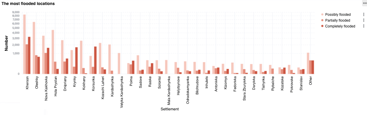
For instance, in the Kherson district, the highest number of buildings were flooded – 6,612. In the Kakhovka district, 4,334 structures were completely flooded, which is the second largest number. The flooding had the least impact in the Skadovsk and Beryslav districts, with only 122 and 93 flooded buildings respectively.
To what extent buildings were flooded
The good news is that not all structures at the disaster’s epicenter were submerged. Some of them remain entirely undamaged.
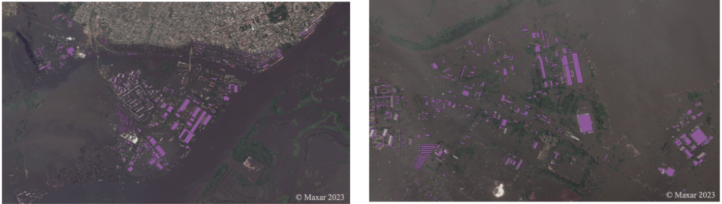
The bad news is that there are a lot of flooded buildings, as evident from satellite imagery. As a result of the dam explosion, 11,367 objects were completely submerged, with the water rising above three meters. Another 6,580 structures were partially flooded, which in our methodology means that water reached between 1 and 3 meters.
In the left photo, the pink-colored areas indicate flooded buildings in the Korabel micro-district in Kherson, and the right photo shows the western part of the Oleshky town. These satellite photos were taken on July 6, 2023.
It is reassuring that the majority (42,560 buildings) fall into the category of possibly flooded, meaning that the water did not rise above one meter in these structures. In such cases, they can be repaired if they have a solid foundation.
However, these are preliminary estimates. In order to confirm or refute them, further detailed investigations are necessary because most of the objects in this area are private houses, each of which is unique. Many of them are built on clay soils, which may appear sturdy, but they might not withstand the winter as the foundation can shift.
What these data are used for
The recovery of the affected areas requires significant funding, including from donors and investors.
All the agreements and financing arrangements with international partners, from the declaration adopted at the Lugano Conference to the list of reforms published this week for U.S. funding, include a requirement to Ukraine to ensure transparency of the reconstruction process.
Constant monitoring of the extent of flooding in the Kherson and Mykolaiv oblasts following the destruction of the Kakhovka Hydroelectric Power Plant can provide both independent confirmation of the level of destruction and the necessary transparency in the process of rebuilding these areas. Analyzing geospatial data from satellites and drones can help objectively determine priority areas and regions for reconstruction, verify the needs of the affected population, develop more efficient regional recovery strategies, and enable informed budget planning for projects.
All the data is already available on a public dashboard, meaning anyone in Ukraine or abroad can implement their own analysis. Our team plans to regularly update analytical reports on the situation. This level of openness and transparency will help effectively overcome the consequences of the Russian terrorist act, ensuring trust, and maximizing the involvement of investors and donors in this process.
This publication has been prepared using data provided by the EMITTER project, implemented with the financial support of the European Union. Its content is the sole responsibility of the project and does not necessarily reflect the views of the European Union.

Attention
The author doesn`t work for, consult to, own shares in or receive funding from any company or organization that would benefit from this article, and have no relevant affiliations